

Talk to an Expert

|
Dale Hylton - Sales Engineer 844-474-8833 x2 |
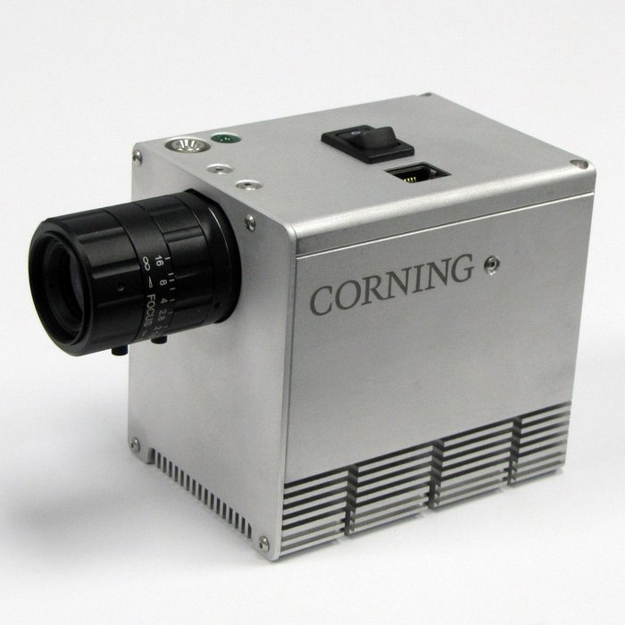
A few of the 410 SHARK’s innovative features include:
- First complete, coherent HSI sensor system designed specifically for small UAS/UAV drones
- System includes: – visNIR microHSI™ 410 sensor – Lens – GPS/Inertial navigation system (INS) – Microprocessor control – Data acquisition and storage
- Dimensions: 136.4 x 87.4 x 70.4mm (with lens) / 95.8 x 87.4 x 70.4mm (without lens) • Weight: 730 grams
- Web interface for system management and control
- Flight planning and execution software enables preprogramming of image collection plan
- Automated waypoint operation, frame rate, binning, selectable image recording options
- Operating and maintenance documentation
- API interface (upon request)
- Designed for minimum 30 minute operating/recording time.
- Consistent with performance of most small UAS
- Hot-swap battery optional; larger battery available
- For more effective data management, the user can choose to collect the entire 155 band hyperspectral image cube, or only the spectral bands needed for a specific mission or application.
- Digital Elevation Maps (DEM) can be loaded into the system pre-flight for the area to be imaged to improve image georegistration during post-processing.
- Spectral Range: 400nm-1000nm
The 410 SHARK is the lowest cost integrated airborne hyperspectral imaging system on the market today.
Hyperspectral vs. Multispectral Imaging Technology
- Hyperspectral imagers cover many dozens to hundreds of spectral bands contiguously
-
Multispectral imagers cover a selected set of bands non-contiguously
- Spectral information critical for characterization, research and development of specific applications may be missing.
- Number of spectral bands is insufficient to address multitude of developed and proven applications and indices.
Why Hyperspectral Over Multispectral for Precision Agriculture?
- Agricultural market demand for hyperspectral sensor systems is growing to address a growing catalog of vegetation indices used for vegetation/crop analysis and diagnostics.
- There are currently over proven 65 vegetation indices, and growing
- New crop specific, application specific indices are being developed and introduced each year.
- Multispectral sensor systems can utilize only a small subset of indices, and cannot take advantage of new indices as they are introduced.
- Hyperspectral sensors enable the research and development of new vegetation indices – multispectral sensors do not.
Corning MicroHSI 410 Shark - Use Cases
Crop Growth and Health Assessment/Management
- Enables the evaluation of vegetation stress, often before it is visible to the human eye or with other sensors.
- Enables the visualization of change in crop growth and health, and yield prediction throughout the growing season.
- Data products: NDVI reNDVI, Senesis and dozens of other indices
Olive Orchard – Zamora, CA
In less than 48 hours…
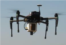
- The microHSI™ 410 SHARK and miniature UAS were integrated, tested and flown, and high quality geo-referenced data sets were produced.
- Entire system weighed less than 3.7kg including payload and battery
Nitrogen Fertilization Recommendation
NASA ROSES Program
- Corning visNIR microHSI Sensor/System was flown over shallow reef, sea grass in Florida Keys for climate change assessment study
- Platform: rotary wing UAV
- Data extracted immediately after flight for processing
- System operated without interruptions during 2 week campaign
- NASA Group Achievement Award - 2014
Our on-line store is open 24/7 and we ship Monday through Thursday, excluding some holidays. Orders received for products without shipping restrictions on its product page will ship the same business day when received before 12:00 p.m. PST. Orders in high demand will have an estimated time listed on its product page and will ship according to the date listed.
Signature is required for most shipments.
*How long does it take for you to ship a product?*
This depends on your location, the method of shipping and the item you choose.
For in stock items inside the USA we typically ship by UPS and FedEx and for small items we ship by USPS. We typically ship items within 1-2 business days of the order for in stock shipment.
Ground Shipments can take up to 5 Business days from our Washington location. Express options are available by contacting us, but UPS and FedEx do NOT guarantee any shipments at this time.
If there are lithium batteries (most drones & ROVS), these cannot be shipped express.
USPS typically takes 2-3 business days for the smaller items by priority mail.
Special Order items can take time to arrive, but once they arrive we ship them out right away.
SHIPPING NOTES:
- Orders under $50 = $25 Ground Shipping & Handling
- Orders $50-499.99 = $20 Ground Shipping & Handling
- Orders $500 or higher = FREE Ground Shipping & Handling (USA Only)
- Alaska & Hawaii have unique shipping starting at $125
- Contact us for Express Shipping Options
- DHL & UPS Available for International Orders*
*International shipments are typically sent by DHL or UPS. Please note you are responsible for any customs fee, taxes and brokerage fees that may be due by importing an item into your country.
Frequently Asked Questions
Do we offer Financing? The short answer is YES we do!
To determine the best financing option, we need to determine if you are interested in a personal financing option or if you will be using a business to finance your purchase.
 BUSINESS OPTIONS:
We work with 2 different companies for financing. Each Organization has their own criteria for purchases. These Financing options are for US customers only.
-
BNC Financial
Specializes in equipment funding from $500 and up. Follow this link to to the the financing application. -
First Pacific Funding
Financing options from $5000 and up. Follow this link to go to the financing application. - APPROVE Commercial Financing. Add an item to your cart, then click on the APPROVE logo for an inline application on the right hand of your screen. Monthly Payments and rates vary depending on final terms.
https://financing.approvepayments.com/blue-skies-drone-shop
 PERSONAL OPTIONS:
- Affirm
Buy now, pay later without the fees. Affirm is the smartest way to pay over time. Shop pretty much anywhere and pay at your own pace without any fees, so you can get the things you love without breaking your budget.
Affirm is built into our website. Click on the product you are interested in purchasing, then click on the 'Pre-qualify now' link.
Click Here to see the details on how it works -
Shop Pay
This payment option works similar to Affirm. If you do not see the shop pay option on the product page, click on "More payment options.
The Look for the button.