


Talk to an Expert

|
Dale Hylton - Sales Engineer 844-474-8833 x2 |
Make the World Your Digital Asset
Automatic Flight Planning and Data Capture
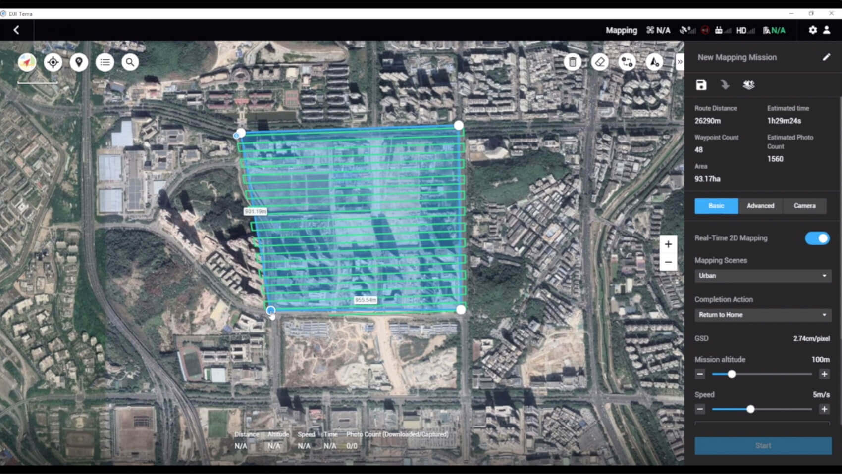
DJI Terra helps commercial drone pilots quickly plan automated flights with several easy-to-use options based on the area or objects they’d like to capture and the type of map or 3D model they’d like to create. It features three mission planning types:
- Area: Capture a specific area quickly and easily by drawing a custom polygonal flight zone on a map. DJI Terra automatically generates efficient flight path options based on the area selected.
- Waypoint: Create dynamic custom flight paths through an area or around objects using waypoints and adjustable parameters like aircraft altitude, speed, heading, gimbal pitch and angle. For more complex missions that require high attention to detail, the 3D Flight Visualization feature enables the design and simulation of missions on existing 3D models.
- Oblique: Capture a rich data set by automatically flying the same route multiple times. Each flight automatically adjusts the angle of the camera to capture new details, giving an extra crisp 3D model of the object or asset from multiple angles.
Real-time Mapping and Detailed 3D Models
- Real-time mapping: DJI Terra allows drone pilots to quickly generate 2D orthomosaic maps as the drone flies, ideal for time-sensitive missions where situational awareness is critical and decisions need to be made in minutes.
- Fast processing capability for efficient reconstruction: With DJI Terra, users can efficiently generate realistic representations of any environment through detailed 2D orthomosaics and 3D model reconstructions, used for industrial applications like reconstructing vehicle crashes, tracking progress on construction projects or conducting large-scale critical infrastructure inspections on bridges and roadways.
Easy Data Analysis
- 2D and 3D Measurement Tools: analyze data and generate instant insights with easy-to-use analysis tools that provide a variety of measurements including linear distance, surface area and volumetric estimations.
- Annotation: To improve team communication and reporting throughout ongoing projects, annotation labels can be edited and shared.
- Photo Inspection: Ideal for detailed site inspections and accident reconstruction situations, DJI Terra’s photo inspection tool lets users closely examine every photo used to create the model so they can pinpoint and highlight critical elements.
Our on-line store is open 24/7 and we ship Monday through Thursday, excluding some holidays. Orders received for products without shipping restrictions on its product page will ship the same business day when received before 12:00 p.m. PST. Orders in high demand will have an estimated time listed on its product page and will ship according to the date listed.
Signature is required for most shipments.
*How long does it take for you to ship a product?*
This depends on your location, the method of shipping and the item you choose.
For in stock items inside the USA we typically ship by UPS and FedEx and for small items we ship by USPS. We typically ship items within 1-2 business days of the order for in stock shipment.
Ground Shipments can take up to 5 Business days from our Washington location. Express options are available by contacting us, but UPS and FedEx do NOT guarantee any shipments at this time.
If there are lithium batteries (most drones & ROVS), these cannot be shipped express.
USPS typically takes 2-3 business days for the smaller items by priority mail.
Special Order items can take time to arrive, but once they arrive we ship them out right away.
SHIPPING NOTES:
- Orders under $50 = $25 Ground Shipping & Handling
- Orders $50-499.99 = $20 Ground Shipping & Handling
- Orders $500 or higher = FREE Ground Shipping & Handling (USA Only)
- Alaska & Hawaii have unique shipping starting at $75
- Contact us for Express Shipping Options
- DHL & UPS Available for International Orders*
*International shipments are typically sent by DHL or UPS. Please note you are responsible for any customs fee, taxes and brokerage fees that may be due by importing an item into your country.

At Blue Skies Drones, your safety and confidence while flying are always a top priority. That’s why we’ve partnered with SkyWatch—a trusted name in drone insurance—to help ensure you’re protected every time you take to the skies.
Whether you're flying recreationally or professionally, SkyWatch offers flexible and affordable coverage options tailored to your needs. Choose from hourly, monthly, or annual plans, so you can fly with peace of mind—on your terms.
👉 Coverage available exclusively for customers in the USA and Canada.
![]()
Why Drone Insurance Matters – And Where to Get It
Flying a drone can be exciting and rewarding—but it also comes with risks. While drone insurance isn't always legally required, it’s highly recommended to protect yourself, your equipment, and others around you. Whether you’re flying for fun, professional photography, or commercial inspections, having the right insurance offers peace of mind and may be required by clients or job sites.
💡 Why You Should Consider Drone Insurance
🔹 Liability Coverage
Protects you financially if your drone causes property damage or injury to others.
🔹 Damage Protection
Covers repair or replacement costs if your drone is damaged due to crashes, hard landings, or environmental hazards.
🔹 Theft Coverage
Helps recover losses if your drone or gear is stolen.
🔹 Client & Regulatory Compliance
Many commercial projects, job sites, and government contracts require proof of insurance before allowing flight operations.
🔹 Peace of Mind
Know you’re covered—legally and financially—so you can focus on flying with confidence.
🛡️ Types of Drone Insurance
✅ Liability Insurance – Covers third-party injury and property damage.
✅ Hull Insurance – Protects your drone and payload (like cameras or sensors) from physical damage.
✅ Personal Injury Insurance – Covers medical costs for you or your crew during drone operations.
✅ Commercial Drone Insurance – Designed for businesses with multiple drones/operators, offering bundled and comprehensive policies.
📍 Where to Get Drone Insurance
-
Specialized Drone Insurers (like SkyWatch.AI)
-
General Insurance Providers with UAV policy options
-
Aviation Insurance Firms with experience in drone operations
⚖️ Is Drone Insurance Legally Required?
In the United States, the FAA does not require insurance, but many local governments, private clients, and commercial contracts do. It’s especially crucial if you’re flying professionally or in public spaces.
✔️ Before You Fly
Check with your current insurance provider to see if they cover drone rentals or flight operations. If not, we highly recommend securing coverage before you launch.
We’ve found that SkyWatch.AI offers affordable, flexible, and user-friendly options for drone operators of all levels.