


Talk to an Expert

|
Dale Hylton - Sales Engineer 844-474-8833 x2 |
Reasons to Choose UgCS Expert
-
Reduce LiDAR flight-planning time by up to 3×, allowing the software to pay for itself within 1–2 projects.
-
Use industry-leading LiDAR flight-planning algorithms to improve data quality.
-
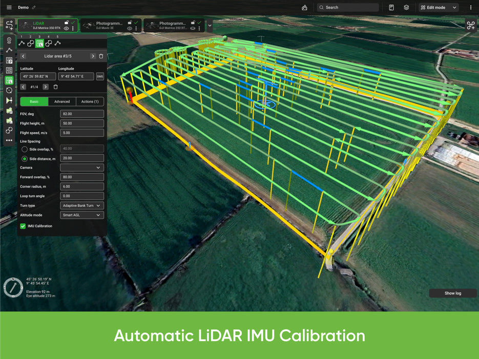
Automate IMU calibrations with built-in figure-eight, U-shape, and automatic L1 calibration patterns.
-
Includes all the capabilities of UgCS PRO plus dedicated tools for LiDAR surveys.
-
Maintain precise distance to terrain and structures using the Smart AGL algorithm.
Applications by Industry
Construction: Site surveys, road corridors, bridge and dam inspections, vertical facade mapping
Energy: Powerline and tower inspections, solar farm surveys
Oil & Gas: Pipeline inspections, infrastructure monitoring
Agriculture & Forestry: Crop health monitoring, large-area missions (>10 ha), DEM/DSM data collection
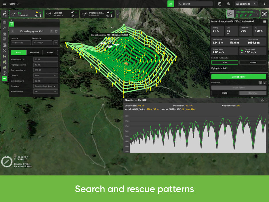
Search & Rescue: Large-area search flights over uneven terrain
Mining: Quarry mapping, LiDAR surveys, high-wall inspections in open-pit mines
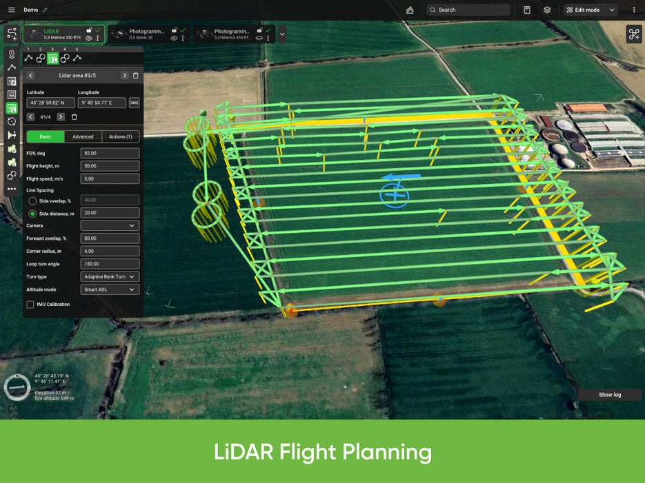
Features of UgCS Expert for LiDAR Surveys
-
LiDAR Area and LiDAR Corridor mission tools
-
IMU calibration route patterns (figure-eight)
-
IMU calibration actions (figure-eight, U-turn / J-hook)
-
LiDAR flight planning based on FOV
-
Adjustable corner radius for smoother turns
-
Loop turns for enhanced IMU calibration
-
New Smart AGL terrain-following algorithm
-
Adjustable LiDAR area buffer size
Additional Features
-
Terrain-following flight planning
-
3D planning interface
-
Offline maps for field operations
-
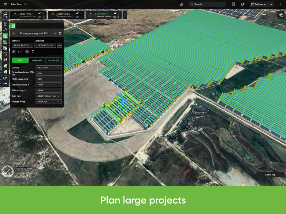
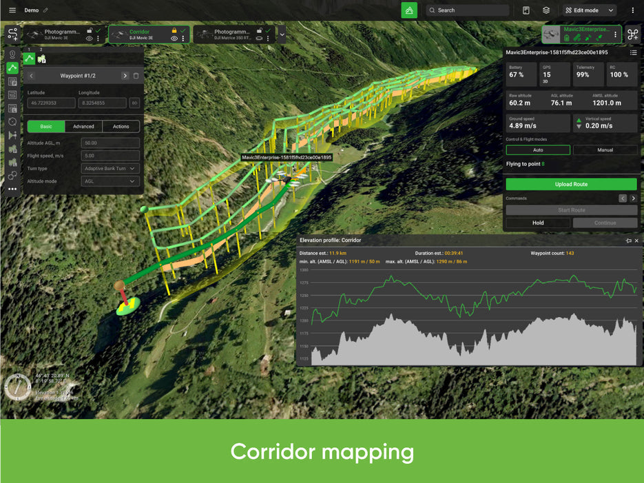
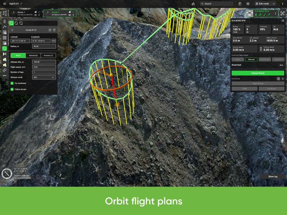
Photogrammetry, Facade Scan, Corridor Mapping, SAR, Linear, Circle, Waypoint, Perimeter, and Area Scan tools
-
KML/CSV route import
-
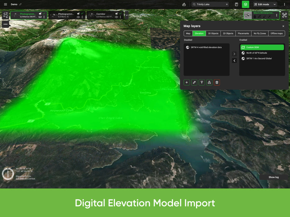
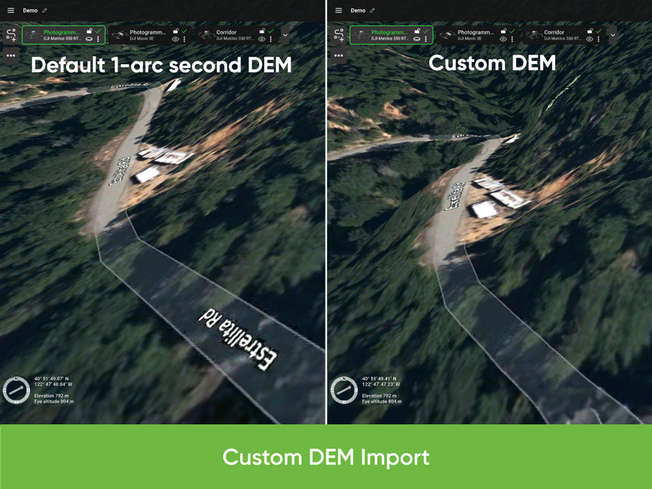
DEM/DSM import (.TIF)
-
Flight preview with elevation profile
-
Automatic telemetry logging
-
Geo-referenced image import
-
Custom no-fly zones (NFZ)
-
Custom map overlays
-
ADS-B receiver support
-
Compatible with UgCS Mapper for imagery processing
Supported Drones
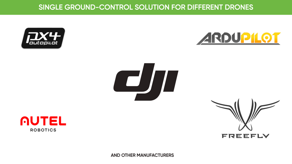
UgCS Expert LiDAR tools currently support:
DJI M300, M350, M600, M2X0 series, and other DJI platforms.
Support for additional platforms is coming soon.
UgCS also supports:
DJI Inspire, Phantom, Mavic series, and MAVLink-compatible drones (ArduPilot/PX4).
Compatible LiDAR Sensors
UgCS Expert is not limited to specific sensors. Most LiDAR units are supported if carried by a compatible drone.
Officially supported sensors include:
DJI L1, L2, YellowScan, Phoenix LiDAR, RIEGL, LIDAR USA, GeoCue, Rock Robotics, GeoSun, 3DT Scanfly, Topodrone, Balko Tech.
UgCS Expert Perpetual License
-
One-time purchase—own it forever
-
First year of updates and support included
-
Annual Support & Update Pack required from year two onward
Technical Details
-
Installs locally on Windows, macOS, and Ubuntu 18.04
-
Uses the UgCS for DJI Android app to connect to DJI drones
Our on-line store is open 24/7 and we ship Monday through Thursday, excluding some holidays. Orders received for products without shipping restrictions on its product page will ship the same business day when received before 12:00 p.m. PST. Orders in high demand will have an estimated time listed on its product page and will ship according to the date listed.
Signature is required for most shipments.
*How long does it take for you to ship a product?*
This depends on your location, the method of shipping and the item you choose.
For in stock items inside the USA we typically ship by UPS and FedEx and for small items we ship by USPS. We typically ship items within 1-2 business days of the order for in stock shipment.
Ground Shipments can take up to 5 Business days from our Washington location. Express options are available by contacting us, but UPS and FedEx do NOT guarantee any shipments at this time.
If there are lithium batteries (most drones & ROVS), these cannot be shipped express.
USPS typically takes 2-3 business days for the smaller items by priority mail.
Special Order items can take time to arrive, but once they arrive we ship them out right away.
SHIPPING NOTES:
- Orders under $50 = $25 Ground Shipping & Handling
- Orders $50-499.99 = $20 Ground Shipping & Handling
- Orders $500 or higher = FREE Ground Shipping & Handling (USA Only)
- Alaska & Hawaii have unique shipping starting at $125
- Contact us for Express Shipping Options
- DHL & UPS Available for International Orders*
*International shipments are typically sent by DHL or UPS. Please note you are responsible for any customs fee, taxes and brokerage fees that may be due by importing an item into your country.

At Blue Skies Drones, your safety and confidence while flying are always a top priority. That’s why we’ve partnered with SkyWatch—a trusted name in drone insurance—to help ensure you’re protected every time you take to the skies.
Whether you're flying recreationally or professionally, SkyWatch offers flexible and affordable coverage options tailored to your needs. Choose from hourly, monthly, or annual plans, so you can fly with peace of mind—on your terms.
👉 Coverage available exclusively for customers in the USA and Canada.
![]()
Why Drone Insurance Matters – And Where to Get It
Flying a drone can be exciting and rewarding—but it also comes with risks. While drone insurance isn't always legally required, it’s highly recommended to protect yourself, your equipment, and others around you. Whether you’re flying for fun, professional photography, or commercial inspections, having the right insurance offers peace of mind and may be required by clients or job sites.
💡 Why You Should Consider Drone Insurance
🔹 Liability Coverage
Protects you financially if your drone causes property damage or injury to others.
🔹 Damage Protection
Covers repair or replacement costs if your drone is damaged due to crashes, hard landings, or environmental hazards.
🔹 Theft Coverage
Helps recover losses if your drone or gear is stolen.
🔹 Client & Regulatory Compliance
Many commercial projects, job sites, and government contracts require proof of insurance before allowing flight operations.
🔹 Peace of Mind
Know you’re covered—legally and financially—so you can focus on flying with confidence.
🛡️ Types of Drone Insurance
✅ Liability Insurance – Covers third-party injury and property damage.
✅ Hull Insurance – Protects your drone and payload (like cameras or sensors) from physical damage.
✅ Personal Injury Insurance – Covers medical costs for you or your crew during drone operations.
✅ Commercial Drone Insurance – Designed for businesses with multiple drones/operators, offering bundled and comprehensive policies.
📍 Where to Get Drone Insurance
-
Specialized Drone Insurers (like SkyWatch.AI)
-
General Insurance Providers with UAV policy options
-
Aviation Insurance Firms with experience in drone operations
⚖️ Is Drone Insurance Legally Required?
In the United States, the FAA does not require insurance, but many local governments, private clients, and commercial contracts do. It’s especially crucial if you’re flying professionally or in public spaces.
✔️ Before You Fly
Check with your current insurance provider to see if they cover drone rentals or flight operations. If not, we highly recommend securing coverage before you launch.
We’ve found that SkyWatch.AI offers affordable, flexible, and user-friendly options for drone operators of all levels.